The Vrmac Massif resembles a giant, green-sprinkled Toblerone bar emerging from the sea, separating Kotor and Tivat with its rugged hillsides.
You can explore this Montenegro natural beauty in different ways as there are several trailheads and interconnected trails with different levels of difficulty. You’ll enjoy scenic views of the bay and the surrounding mountains and walk around an abandoned fort and historic villages.
I started this hike at the trailhead in Muo (the town across Kotor) and ended up in Donja Lastva, Tivat.
This is a day hike, point-to-point (it starts and ends at different points). But you can do shorter hikes to several points of interest and access them in different ways. I divided the route in sections and included a map and tips for alternatives.
Disclosure: This post contains some affiliate links. If you make a purchase through those links I will earn a commission at no additional cost to you (zero, nada). To check the full disclaimer, click here.
This is how to hike the Vrmac Ridge Trail in Montenegro
Table of Contents
Total Hike Summary
Length: 15+Kms (9.3+ miles)
Duration: 7-8 hours
Level of Difficulty: Moderate
The Vrmac Trailhead near Kotor
The closest Vrmac trailhead to Kotor is only a 15-minute walk south from Old Town, right when you reach the town of Muo. Along the main road that embraces the coastline you’ll find the sign (Pješačka staza Vrmac) marking the access point, which will take you up through a residential neighbourhood.


Follow the trail markers – red circles with a white centre or a white line between two red lines and sometimes just red or white arrows- as you meander a couple of alleys and go up several flights of stairs.


At the end of the uneven stairs pictured below you’ll see on your left Road P22 making a sharp curve, on your right a private driveway, and ahead of you a short rocky path with a bunch of pomegranate trees.


Near the trees, to the right, you’ll see some big rocks marked with white paint. Climb over the rocks to step on the switchbacks that will take you to the ridge where you can visit the fort.


See the map below for the start and end point of the section I just described and the entire route divided in sections:
The Vrmac Switchback Trail to the Fort (Franz Joseph Stairs)

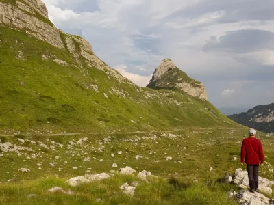
You’ll now ascend along the hillside on a series of rocky and sometimes narrow switchbacks that run through a beautiful pine forest that grows thicker the higher you go.


This is a nice section of the hike, with great views of Kotor Old Town, Dobrota, and the mountainous background.


If you turn left after you complete the last -and long- leg you’ll walk past a farm and head towards Fort Vrmac. You’ll probably run into some pigs and goats roaming around some abandoned buildings on site.


A few more steps will take you to the fortress.
Hike Summary:
Length: 3.3 Kms (2 miles)
Duration: 2.25 hours
Level of Difficulty: Moderate
Note: these switchbacks are not the same as the ones of the Ladder of Kotor. That’s a different trail that starts north of Old Town Kotor. Check out my post about hiking the Ladder of Kotor.
Fort Vrmac (Tvđrava Vrmac)

Fort Vrmac was built in 1860 by the Austro-Hungarian Empire when it took over Kotor. The concrete and stone building was then repaired after being bombed in WWI.
Taking into consideration that it has been abandoned since the end of the Yugoslavia era, it’s not in such bad shape. At least on the outside.
We ventured a few feet into the dark, smelly compound and turned around after seeing crumbling floors open to voids. Kind of creepy. Nope! Back to the hike.

Walk towards the road to the right of the fort to enjoy a view of Tivat and the airport runway, the Luštica Peninsula, and Herceg Novi.

Note: if you want to start the Vrmac Ridge hike from Fort Vrmac you can reach the fort by car from a road off P22.
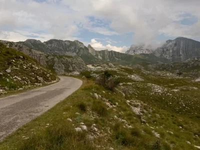
Hike from Fort Vrmac to Sveti Ilija

Retrace your steps, go past the farm, and walk straight along Trail #749 heading north. You’ll soon find a fork on the route. We followed the path on the right as we wanted to be closer to the Kotor side.
You can also take the one on the left, which will eventually connect to the one on the right if you keep right at every fork (you can also complete it as a loop if you don’t want to hike all the way to Gornja Lastva).
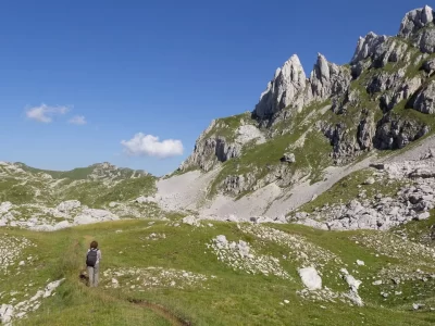
This is the easiest section of the trail as you’ll be walking along the Vrmac ridge. The path is made of small rocks, with a gentle slope, and with clear patches here and there that let you catch great views of both the Kotor and the Tivat sides.


Around 4 Kms (2.5 miles) and about 2 hours later, you’ll reach Sveti Ilija: the highest elevation in Vrmac with an altitude of 785 metres (2,575 ft.). There’s a big concrete platform on site surrounded by jagged rocks. At some point there were plans to build another fort here but it never happened.
This was a great place to take a break and delight in the scenery of the bay of Kotor in several directions and the small towns dotting its foothills.


You’ll also have a good view of inland Tivat and the ridge you just walked on. You can see the trail here and there.


Note: you can also reach Sveti Ilija by mountain bike.
Hike Summary:
Length: 4.2 Kms (2.6 miles)
Duration: 2 hours
Level of Difficulty: Easy
Want more amazing hikes in Montenegro? Durmitor National Park is a great destination for hikers.
Book this hiking day trip, with a 5/5 rating based on more than 60 reviews.
Hike from Sveti Ilija to Gornja Lastva
After you leave Sveti Ilija the rocky path gets rougher and soon after you’ll be going downhill, walking on loose big rocks that make the descent a little bit tricky. Hiking shoes (or boots if you want extra balance) and hiking sticks will make your life easier.
Along the way we stopped to admire some shiny, beautiful, greenish blue iridescent dung beetles.


We followed the trail markers and signs for trail #749b/749mb towards the historic village of Gornja Lastva, where the first settlement occured many centuries ago.
With its stone alleyways you’ll feel like the place is stuck in time and that’s totally intentional as the locals want to preserve their architectural heritage. Most buildings are from the 19th century. Some have been restored, some still need reconstruction.
Some are older, such as the Church of male Gospe built in 1410.


The place is surrounded by abundant fields of pomegranate and olive trees, a sign of an important pillar of the local economy: artisanal olive oil production.
From Gornja Lastva you’ll start seeing views of Tivat’s marina.


Note: if you have time to spare you can take a spur trail (before arriving to Gornja Lastva) that will take you to the Church of Sveti Vid, another ancient church with great views. You can also take another route and descend via Gornji Stoliv and wander around the abandoned stone village founded centuries ago.
Hike Summary:
Length: 5.2 Kms (3.2 miles)
Duration: 2.5 hours
Level of Difficulty: Moderate
Don’t have time to complete the hike? You can go up Vrmac along off roads on a 4×4 vehicle for a walking tour of the historic town of Gornji Stoliv, a taste of local juices, cheese, and prosciutto, and scenic views of the bay.
Explore Vrmac with this tour, with a rating of 4.9/5 based on more than 30 reviews.
Hike from Gornja Lastva to Donja Lastva (Tivat)

This is the last section of the hike (trail 749mb), or the first if you start from this side. It’s a paved, downhill road with closer views of Tivat’s marina, so it’s easy peasy.


Note: If you’re hiking from Tivat you have the option of driving up to Gornja Lastva and start from there.
When you arrive at Donja Lastva, you can walk south on the main road (Jadranska magistrala) and in less than two minutes you’ll find a bus stop where you can hop on a bus (Blue Line) that will take you back to Kotor. Or hail a taxi.
Hike Summary:
Length: 3.3 Kms (2 miles)
Duration: 1 hour
Level of Difficulty: Easy
An Alternative: Hike to/from Lepetane

One of the several trailheads to go up the Vrmac ridge is located in the small town of Lepetane. You could do a longer hike from Kotor and end here instead of Donja Lastva, or go up Lepetane as a separate hike to enjoy different views of the Kotor bay (which is what we did on a separate day).
We went up at Lepetane, but we didn’t connect to Gornja Lastva as the trail going that way was quite overgrown and to make matters worse the signage wasn’t the best. If you plan to tackle that route, download the regional map on maps.me so you can have offline access. It saved our behinds when we got lost.
To find the trailhead you’ll go up the narrow street that starts at the corner where the main coastal road meets the ferry harbour. You’ll see the small Church of Sv Ane at the bottom of the street, on the left side (see the map included for reference).
Walk along the uphill street (you’ll see trail markers along the way) to find the sign for trail #757. You’ll go up rough stone steps and soon enter an enchanting path in the forest with plenty of shade until you’re out in the open.


We ended up right above the ferry harbour, from where we enjoyed great views of Kamenari across the water, of the outer part of the bay of Kotor bordering the Luštica Peninsula, and the inner part towards Risan.


From Lepetane you can connect to the network of trails across Vrmac and end up in Tivat or Kotor, or just take it easy and enjoy the views from here.
Where to Stay near Vrmac
You can stay in Kotor or in the small towns at the foothills of Vrmac. Here are some highly-rated options:
Kotor Nest (Old Town Kotor): guesthouse with shared kitchen, dining table and lounge room. Comfortable rooms with AC, some with ensuite bathroom, some with private external bathroom, and some shared. Some rooms have a private kitchen and terrace. No elevator.
Stay at Kotor Nest, with a rating of 9.1/10 based on more than 1,090 reviews.
Muo Apartments (Muo): sea view units with a well-equipped kitchen, dining area, washing machine, flat-screen T.V., and AC. Free parking and outdoor pool on site.
Check prices and availability; rating of 9.3/10 based on more than 175 reviews.
Hyatt Regency Kotor Bay (Donji Stoliv): stay here for a luxury resort experience. The modern rooms (with sea, pool, or mountain views) have a desk, sitting area, minibar, flat-screen T.V., and AC. Free parking and breakfast included.
Stay at the Hyatt, with a rating of 9.1/10 based on more than 1,990 reviews.
The mountainous geography of Montenegro is ground for many scenic hiking trails like the Vrmac ridge. Do you have time to include another trail with great views in your Kotor itinerary? Check out the Kotor Fortress trail.
YOU MAY ALSO WANT TO READ
BOOKING FLIGHTS AND ACCOMMODATIONS
To get from A to B without losing your shirt
Skyscanner: to find cheap flights. Get notified of price drops with the “Price Alert” feature or use “Search Everywhere” to see where you can go without breaking the bank.
Busbud: to book bus tickets everywhere.
To find a place to stay for less
Booking.com: this site combines everything under the sun. You’ll find hotels, apartments, B&B, hostels, rooms, etc., with all sort of filters to make your search a breeze.
Hotwire: the first site I check when we plan to stay at a hotel for a few nights. You can save anything from 20% to 60%. Use the search filter to find what you want and you’ll end up with three listings that match your criteria. You’ll know which one you’ll get after you book. If you can handle a little bit of uncertainty you can score big savings.
House Sitting: you take care of people’s pets and house for free while staying for free. It’s the closest thing to experiencing a place “like a local”. But it comes with responsibilities… Are you an animal lover? It may become your new way to travel.
To get travel insurance
SafetyWing: travel medical insurance that gives us peace of mind knowing that we’re covered in case of emergency. It’s convenient, affordable, and suitable for digital nomads who spend a long time outside their home country.
Check the full list of travel resources on my Resource Page for more options and savings